
Mars Odyssey
|
Mars Odyssey |
Mars Student Imaging Project Ms. Best's
Third Grade Class Click here to read about the students' work prior to obtaining their data. We made a PowerPoint project for NASA and it was accepted so we were the first third graders to do this NASA project.
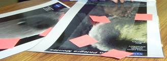
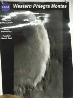
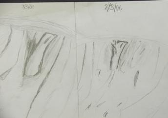
Our question is... "WILL THERE BE CHANGES ON THE CRATER THAT OUR SATELLITE HAS BEEN FOCUSING ON?" After noticing the edges of craters are different and can tell us what happened to them, we posed this question because it seemed very interesting. We looked at many, many pictures on the THEMIS website for days - especially all the craters. We searched for a crater edge visible with possible ice and shapes that would match both our pictures (target and reference image). Then we finally found the picture we were looking for. When we got the picture at first we thought the satellite would take a whole different picture. We needed to know which orbits would be in daylight on our target and we only had a week and a half to choose our target from 12 orbits. Image 1 was taken
on July 3, 2004. It is Image ID# V1131604. Latitude
42.67N, Longitude 159.09E. Image 2 is our image and was taken
on/about February 3, 2006. The Image ID# is V18367043. Latitude
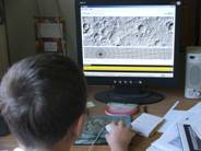
43.80N, Longitude 159.31E. We used the satellite (Mars Odyssey/THEMIS) to take a picture of Mars. The name of the picture we took was of the Western Phelgra Montez. We looked at our new crater "Believe." We have to look carefully for changes and whatever differences we need to study. We used rulers, pencils, and our minds to figure out the measurements of our crater. We worked to see the length between the crater and we found the right edge, gully, dark spot, and a slope streak. We worked hard on the pictures for a long time! We measured the picture we took of Mars. We measured in centimeters and millimeters. First we had to remember how to use the ruler the right way! It was hard and interesting to us. Ms. Best showed us how to organize our measurements in a Table. Then she showed us on the computer how to turn the Table into a Graph! That was so Cool!!!
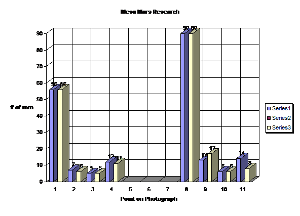
OUR DATA
Here is the Excel graph of the data:
But the footprint measurement was a big difference, so we think there was a big change on that part of the crater. Probably some of the ice melted a little and sunk into the ice around it. This made it "slump" from the edges of the footprint shape and look bigger now. Now we have to see if our guess is right and answer our question. Our question is if ice on the rim of the crater will change in a short period of time? Our hypothesis is yes, we think that we can see changes in a rim of ice on a crater in a short period of time. Our answer is that yes we can see changes in a rim of ice in two years.
Now other scientists can use our work to continue the study of ice, water, and craters on Mars and other planets. Maybe they can check other crater rims they already took pictures of a few years ago and see if they can find the same changes we did. Working as Scientists with NASA and Arizona State University was the most awesome school experience! We Believe!!! For more information about MSIP, visit: http://msip.asu.edu/ Send your questions about Mars Odyssey to: Imagiverse - Ask The Expert - 31 May 2006 |
|||||||||||||||||||||||||||||||||||||||||||
| Last
Updated: 1 June 2006 |
| Home | Contact Us | Credits | Sitemap | © 2006 - Imagiverse Educational Consortium |
 Craters
happen when stuff crashes on planets. What do we know about
craters? We
read books, articles by scientists, and participated in teleconferences
with Arizona State University to learn about craters. We
studied a big crater in Arizona (Barringer Crater) and how it changes
on Earth. Craters' edges change over time because of winds
and maybe water. Ice melts and changes shape when the sun
warms it up. Our glaciers on Earth are always changing.
Craters
happen when stuff crashes on planets. What do we know about
craters? We
read books, articles by scientists, and participated in teleconferences
with Arizona State University to learn about craters. We
studied a big crater in Arizona (Barringer Crater) and how it changes
on Earth. Craters' edges change over time because of winds
and maybe water. Ice melts and changes shape when the sun
warms it up. Our glaciers on Earth are always changing.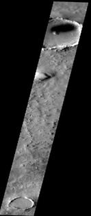
 For our discussion,
we had to write the answers to what we think the changes mean. What
could have happened? The solar angle on the two pictures
was a little different, so shadows could explain small differences. We
think we saw figures inside the crater edge shaped like footprints. One
was little one was big.
For our discussion,
we had to write the answers to what we think the changes mean. What
could have happened? The solar angle on the two pictures
was a little different, so shadows could explain small differences. We
think we saw figures inside the crater edge shaped like footprints. One
was little one was big.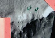 The data that we
collected supports our hypothesis very much because the center
footprint seemed to get a lot bigger in the pictures. The
scientist who looked at our crater edge thinks the curved ridges
"slumped" or fell down to change the shape. It
happened partly from gravity, and partly from water or ice mixed
with rock shifting and moving.
The data that we
collected supports our hypothesis very much because the center
footprint seemed to get a lot bigger in the pictures. The
scientist who looked at our crater edge thinks the curved ridges
"slumped" or fell down to change the shape. It
happened partly from gravity, and partly from water or ice mixed
with rock shifting and moving.