Arizona
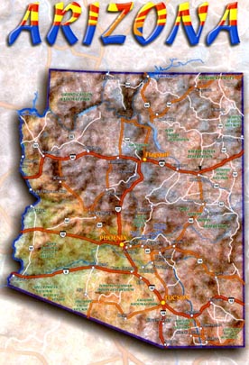
This postcard shows a roadmap of Arizona. Interstate 10 goes from California all the way to Florida! It is the southernmost route for those driving across the United States. From Arizona it dips south, through the southern edge of New Mexico and into Texas, through the cities of El Paso, San Antonio and Houston. Where does it go from Texas? Find Houston on a road map of the United States and trace the rest of the path to Jacksonville, Florida. Further north, Interstate 40 takes you through Flagstaff, Arizona and eastward to Wilmington, North Carolina. Which states will you pass through if you took this route east from Arizona? Where would you end up if you traveled west?
Do you know the significance of the colors in the word "Arizona" at the top of this card? The colors and the placement of them means something special.
| Home | Contact Us | Credits | Sitemap |
© 2006 - Imagiverse Educational Consortium